Background to a discovery
The encounter was as innocent as it was unexpected. It was 1988 and I was being taken behind the scenes of the State Library of Victoria, up into the ‘stacks’. These were the areas of onsite storage that filled the spaces above the Library’s magnificent domed reading room and in truth it should have been out-of-bounds for an outsider like me. After wandering around the multi-level colonnades for some time, the full scale of the collection had begun to blur in my mind, until I came upon something unexpected. Behind one of the pillars sat a display pedestal with a massive book open, displaying maps—old maps. It took a while to get the subject of the maps into focus, but it dawned on me that this was Paris. And as I slowly turned the large pages, I realised that, with each new map, I was being taken back in time to some of the earliest visual conceptions of Paris as a distinct city.
The encounter was fleeting, but the impact on me was profound and persistent. Years later, I sensed that this experience of peeling back the layers of Paris in a book had influenced my aesthetic language as a printmaker. I also suspected that it had lent a new perspective to the way I articulated the world in other aspects of my life, not least of which was as a radio program-maker.
It was another 18 years before my memory of the object at the centre of all this ripple-effect revived itself and prompted my decision to hunt it out. But there was a problem—I didn’t know the title and my creative attempts at searching in the State Library’s catalogue revealed … nothing. Not to be deterred I mentioned the book, as I remembered it, to the inimitable Dianne Reilly, who was then the State Library of Victoria’s La Trobe Librarian. At this point I must credit Dianne with being responsible for starting much that has transpired since, for which I am eternally grateful. Dianne heard the word Paris and her antenna for anything that allows a conversation about the French capital seemed to quiver with delight. No sooner had I mentioned my dilemma, and Dianne had spoken to the Head of Rare Books, Des Cowley, and the Manager of Collections and Access, Shane Carmody. From then on I was in the hands of this triumvirate of Library heavyweights.
Des Cowley vaguely recognized the book from my description and, after some serious searching, located the elusive map collection—complete with erroneous catalogue reference, which naturally rendered the book invisible, in spite of its huge size. In fact two volumes were discovered, the collection of maps and an index, together under the title of the Atlas des Anciens Plans de Paris. It was published in 1880 and given to the library as a gift from France to the people of Melbourne at the time of the first Melbourne International Exhibition of 1880-81. I was thrilled—the book was exactly as I’d remembered it, utterly mesmerizing.
The Gift
Roll forward three years and two attempts (one of them successful) to gain a Creative Fellowship at the State Library in order to find out more about ‘my’ Atlas. Part of the problem of locating the book in the first place was the way it had been catalogued, not under its individual title, but under a series title—Histoire Générale de Paris. So, at the start of my Fellowship, I started to use this series title in my searches, and magically this revealed another book in the collection, with the author listed as Baron Von Haussmann. I excitedly put in a request for this newly discovered book and quickly got a call back from the Library’s book retrieval department:
Which one do you want?
What do you mean ‘Which one’?
Well, there are twenty books here.
[long pause]
… I guess I want them all please.
I couldn’t believe what I’d heard. It turned out that these books had been sitting, untouched, in the General Stacks of the Library. I asked Des Cowley if he knew of them and he said no, and admitted he had no idea why they were not in the Rare Books collection. Suddenly, a trolley with twenty exceedingly dusty volumes arrived in my office at the Library, and I think that was the moment my project started to lurch onto a different course. However, this was only week one.
My second week began with another seemingly simple request for the Library’s accession records of all these books, hoping for details of provenance. A few days later and another Rare Books librarian, a wonderful woman called Jan MacDonald, rang me to say she was sorry for the delay in delivering the information, but she was still counting up all the records of books that had been part of the gift from France to Melbourne—she was currently up to fifty books, but suspected there were many more. My simple project was rapidly morphing into a monster, which was confirmed when the final list came in at approximately one hundred and seventy books, with doubt over whether a few of the titles did actually belong to that original gift in 1880.
The Books
By now, you must be wondering what all these books are, and there’s no simple answer to that. They don’t all fit under the Histoire Générale de Paris banner, although they were all published across much the same period of time. For example, the first book in the Histoire Générale de Paris series was published in 1866, and that series seems to continue on long after the twenty or so volumes that the State Library of Victoria owns, with new volumes being published into the early 1900s. More broadly though, many of the books were published by the variously named Imprimerie Impériale/Royale/Nationale—at different times France’s government, royal or revolutionary publisher. This means that the books largely share a common look—covers, bindings, end-papers—while varying in format, depending on the contents.
The range of topics across these books (see Appendix I) is as vast as it is, sometimes, bizarre. Atlases, photos-albums, reproductions of artwork, histories, inventories, designs for public buildings and other city infrastructure—the list goes on. However, over time, I’ve started to develop some theories as to both the range and the reason for these choices as a gift to a foreign city. The Histoire Générale de Paris series alone (see Appendix II) was a monumental undertaking, attempting to reflect all facets of the creation of the French capital—topography, geology and archaeology; architecture and art; libraries and collections; the military and the mercantile.
Beyond this series of 22 books, the subjects range in ever more unusual directions. However a great many are attempting to take snapshots of Paris’ transformation, from an organically evolved agglomeration of medieval communities, into what is probably the first deliberately reconfigured and modern city. The books in this collection have about them the quality of a grand statement, not just about what has passed, but about what is and what is about to be. The reason is that many of these books were created by the very architects of the new Paris—starting with Haussmann, Prefect of the Seine under Napoleon III, and continuing with one of his successors, Ferdinand Duval. So we see in these books the blueprint for a city that has the imagination to be both coherent in form and functional in practice.
At this point I should, perhaps, return to the subject of maps. This collection of books includes no fewer than thirteen separate volumes of plans of Paris, and while the Atlas that originally caught my attention (and which I’ll talk about in detail shortly) is a reflection on time and the imagination, the other volumes are far more business-like templates for modern and civilised urban living. While the Atlas des Anciens Plans de Paris was a reverie on the evolved City, both real and imagined, these other Atlases showed radical structural innovations—e.g. the reticulation of water to every property in Paris; the connection of every property to a closed and vast underground sewerage system; the complete and mathematically accurate triangulation of Paris, providing accurate data for much more radical building and engineering projects. And in these grand utilitarian statements lies the brilliance of the 19th century conception of Paris.
It is, however, this very clinical portrayal of Paris that highlights the deliberate distinction being made between 12th century Paris and all that’s gone before. I believe that the Atlas des Anciens Plans de Paris was included in this group of books precisely because it was a way of saying ‘That was who we were in another era, but this is who we are now.’ It was a mechanism for distancing the rational, highly engineered present from the quaint, but pre-enlightenment past. And it’s this drawing of a line in the sand that I find most interesting, because it signifies one of those rare moments history—a pivot point between the old and the radically new; a moment where it’s still possible to see in both directions; a moment when the more optimistic in society might still harbour a belief that there exists the possibility of both—the best of the old and the new. Even at this distance of 150 plus years, I can share that romantic desire to hold onto a fading memory, while embracing the heady chaos of the future.
Quite apart from the grand flourish that the Parisian powers were making with many of these books, there were other, far more urgent reasons for documenting so much of the City’s history and structure. One reason was that the creation of new Paris inevitably meant the obliteration of a fair amount of old Paris, and as much as people like Haussmann and Duval believed in their progressive projects, they also recognised that the past must be remembered. The other reason, and possibly the impetus for such practical nostalgia, was that so much of Paris had been destroyed or damaged in the previous decade. Both the internal struggle of the Paris Commune (1871) and the external assault of the Franco-Prussian War (1870-71), had left the French capital with deep scars and a very real sense of fragility. For the City’s guardians, this was heightened by the loss of many of the Paris archives as the Communards destroyed the Hôtel de Ville in May of 1871.
The Atlas
The creation of Atlas des Anciens Plans de Paris is emblematic of much of this deep anxiety about the potential loss of the buildings, objects and archives that embodied the collective consciousness of Paris. In the chaos of 1870-71 some of the most famous historical maps of the City had been destroyed, prompting a desperate search for copies or duplicates in other collections around Paris. The Atlas was conceived as an insurance against more losses and so a set of reproductions of all the most significant and defining maps depicting both the real and the imagined creation of Paris was commissioned. The choices made for this set were informed by a major essay by Alfred Bonnardot1. The maps they chose fell into three distinct categories:
- Maps as curiosities—fanciful and wildly inaccurate
- Maps that were original in their time
- Maps that displayed great geographic and mathematical accuracy for their time
These maps mostly failed the test of ‘modern’ science, and they certainly made the 19thC maps look cutting-edge. But the old maps served other purposes as well because they also told stories, and it’s this aspect that was being largely jettisoned by the progressive 19th C French. Oddly enough, a lot of 21st C cartography is using technology to return to an earlier age of multi-function maps. We’re becoming used to maps that can be multi-layered, especially with online tools like Google Map.
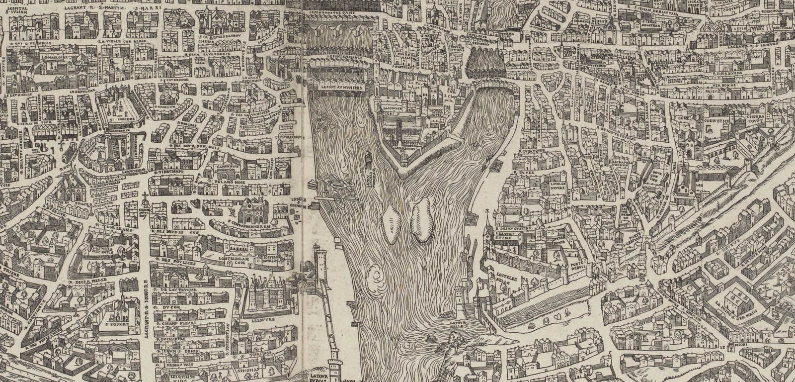
The ancient maps in the Atlas came from an era when a map took on cosmological, religious and political connotations and was able to reflect a society back to itself. In these maps people saw themselves—e.g. the famous Plan de Bâle (see Figs.1 and 2), created by Olivier Truschet and Germain Hoyau in 1552, where we see an almost census level of detail—every inch of the map displaying extraordinary pictures of life in Paris. And for the people of Paris, this world was familiar and mathematical accuracy was far less important than good story-telling. It was a period when the world outside the borders of the map was unknown to the common citizen, and so a map-maker could hint at either the most fantastical or the most frightening things living beyond a mountain range or a forest or a river. So a map was a form of tribal affirmation and reinforcement—it allowed a society to project the best of those who lived inside the map, and the worst of those that lived beyond.
The other aspect was the power of ‘spin’ in the map-maker’s portrayal of their city. Many of the early maps showed Paris contained in a circle—orb-like, planet-like—because, to the great powers of Europe and the church, this shape was a heavenly symbol, bestowing great power and status on the City. It mattered little that this was a distortion of reality, because perception was everything, and after all, no one was about to go out there with a ruler to check.
Strangely enough, almost a century and a half after the Paris bureaucrats republished these maps as oddities, dismissed as inaccurate creations of whimsy, we can see that their 19th C fixation with the future doesn’t distance them from the past as much as they might have wanted. In the Atlas des Anciens Plans de Paris, we see a very clear narrative towards modernity and we can be grateful that, despite the motivation for its publication, for us it’s a valuable document in the story of Paris.
The International Exhibition of Melbourne 1880-81
But why would the French authorities decide that this eclectic array of books would be of interest to the citizens of Melbourne. Of this question, there is no definitive answer. We know that the gift was made to coincide with the Melbourne International Exhibition of 1880-81, but almost no information exists as to the logic behind the gift or the individual selections. Sadly, many of Melbourne’s archives relating to that period in Melbourne were destroyed in a fire in 1952, which, ironically, were housed in a wing of the very same Exhibition Buildings that were constructed for the 1880 event.
Even my visit to various archives in Paris in late 2009, while making some other extraordinary discoveries, uncovered little that could shed light on the gift itself (more about that later). So alas I’m left with little more than my theories, for what they’re worth.
Perhaps the most far-fetched theory is that, at a time when Melbourne was (briefly) the wealthiest city per capita in the world, the architects of Parisian rebirth may have seen Melbourne as a potential client for new 19th C French technology and urban development. Were these books partly intended as a tender document, hoping for a contract to build the Victorian capital city? If that was their hope, they would have been disappointed, because there is a decided lack of French influence across the built landscape of Melbourne.
Another thought is that this was simply an attempt to trigger a cultural conversation between two ‘new’ cities—one city reborn out of the old and the other being formed partially on the back of gold discovery. This must have made Victoria look like a fantastical ‘el Dorado’, with all the attendant mystery that such an image conjures. At a time when the concept of globalisation was in its infancy, any opportunity to court wealthy and culturally interesting allies would have been pounced upon.
The other, possibly most compelling, theory simply has to do with the status of the International Exhibitions at that time. These events were must-attend events for globally-minded countries and hosting an International Exhibition was seen as evidence of an internationally progressive city. Whether or not this was hype, perception would have translated to reality, just as today cities see major events like the Olympics or the World Cup as mechanisms of global ascendency. The truth is probably that France wouldn’t have expected to make any significant inroads into a British colony, but visibility was important regardless. After centuries of France engaging in competitive colonisation, it was important not to drop the ball, and so being seen to be a major ‘player’ on the world stage was critical.
Therefore, alongside exhibition stalls full of pianos, industrial machinery, food, wine and any number of other displays of manufacturing excellence, the books that France gave to the people of Melbourne were also intended as exemplars of publishing, photography and photo-reproduction, quite apart from any cultural import that could be gained from the contents of the books. For example, the volume titled Ville de Paris, published by the Préfecture de Police, is an astonishing collection of crime-scene photographs. However the images are less important than the idea that this relatively new technology could be harnessed in the cause of solving crimes—this was a radical idea at the time. So it seems that everything had an agenda.
The Paris Archives
Now, at this late stage of the story I think I should confess to some of the things that I am not—I am not an historian, I am not a French specialist, I am not a fluent French speaker or reader. In fact I possess few of the attributes that recommend me to take on the study of these books—except for the simple fact that I find them spellbinding. However, the next part of this journey was always going to be a stretch for me. As I’ve already mentioned, in late 2009 I decided to go to France to explore various archives in Paris. The rationale for attempting to do this was the marked absence of archival information in Melbourne, due to the previously mentioned 1952 fire, which had left such a gap in our understanding of the 19th C period of Melbourne’s history surrounding the two International Exhibitions.
With much support from people at the Australian end—including the State Library of Victoria, French Cultural Attaché Sylvie Christophe and Alliance Française de Melbourne’s Director Patrice Pauc—and some unexpectedly kind help, on the ground in Paris, from Monash University’s David Garrioch, I managed to penetrate the bureaucratic barriers at various archives. One by one I scaled the walls of the Archives Nationales, the Bibliothèque Historique de la Ville de Paris (BHVP) and the Bibliothèque Nationale de France (BnF). And although none of this was easy or straightforward, I experienced the most extraordinary generosity from staff who tried very hard to make the processes of gaining access a bit less stressful.
In the end I found useful information in all three institutions, but the great windfall came on my first day at the Archives Nationales. A couple of cataloguers, who were magically able to intuit my wishes from my garbled questions, pointed me directly to the correct place in the catalogues—having said that, there is nothing straightforward or familiar about the French approach to cataloguing. A short time buried in these records convinced me that there were, in fact, many boxes of documents relating directly to the two Melbourne International Exhibitions 1880 and 1888.
The next three weeks involved my navigating a series rolling strikes which shut many cultural institutions, including the Archives Nationales. However there were enough gaps to sift through six boxes of loose documents, letters, catalogues and miscellaneous shipping manifests, labels, exhibition plans etc., to realize that I’d stumbled upon a small goldmine. I phoned Melbourne Museum Senior Curator Charlotte Smith, who I’d spoken to before my departure, to tell her what I’d discovered. I could tell from her sounds of unqualified delight down the phone that this was indeed a good find.
I had gone to Paris without any undue expectation of discovery. I most definitely was not ideally equipped to record the vast amount of archival information I stumbled upon. And so I returned to Australia with some photographic documentation, but more importantly a determination to return to Paris and so that I might fully explore these records. In the meantime, the Melbourne Museum is sending Charlotte Smith to capture as much of the collection as possible at the Archives Nationales.
In the short-term my task is to curate an exhibition, on behalf of the State Library of Victoria, at Alliance Française de Melbourne in St Kilda, to celebrate their 120th anniversary. In the long-term I hope to return to those French records to research a number of topics, one of which is the story of the French Consul-General to Melbourne at the time of the 1880-81 Melbourne International Exhibition, Monsieur Jules Belcour. Through the medium of his letter writing, I got to know M. Belcour very well during my time in the Archives Nationales, and I think more people should be allowed to make the acquaintance of this little-known, but quite extraordinary character. So I suspect that the Atlas will be dictating my paths and determining my future for quite some time to come. I’m not complaining.
1 Études Archéologiques sur les Anciens Plans de Paris: des XVIe, XVIIe et XVIIIe Siecles (1851) by Alfred Bonnardot [return to text]
Article by Michael Shirrefs published in Explorations No 48, June 2010—the journal of ISFAR
© 2010, Michael Shirrefs & ISFAR